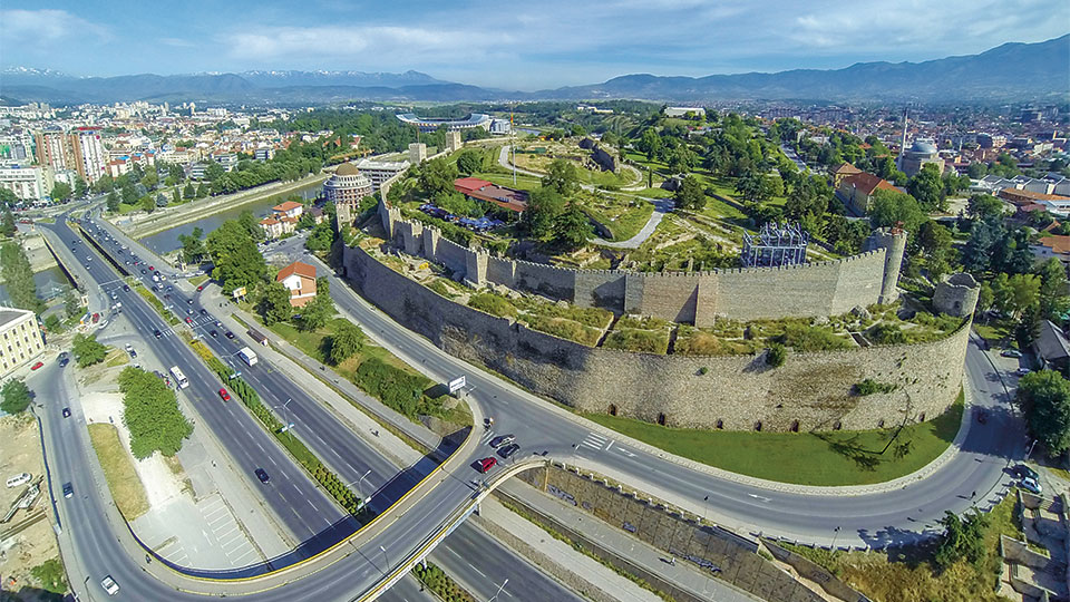
SKOPJE FORTRESS - SKOPSKO KALE
On a high cliff overlooking the river Vardar, Skopje’s fortress has kept a watchful eye for centuries. Being the highest point in Skopje, Kale has always been prized by local inhabitants. Long before the Turks created the extensive castle walls that stand today, settlements had existed here. The earliest traces of life date back to the Neolithic period and early Bronze Age, about 4,000 years before Christ.
The fortress was originally built by the Byzantines in the 6th century A.D, with stone walls that are about 121 meters (400 feet) long. After the 1963 earthquake, Kale’s circular, rectangular and square towers were conserved and restored.
Kale today is one of Skopje’s best sightseeing places offering a fantastic view of the city and proximity to the sites of the city’s Ottoman old Bazaar.
THE MEGALITHIC OBSERVATORY KOKINO
The Megalithic Observatory Kokino is located about 30 kilometers northeast of Kumanovo. This site has a diameter of 100 meters and is scaled on two levels underneath the mountain peak Tatikev Kamen at an altitude of 1013 m. When discovered in 2001 it was believed to be a special mountain sanctuary from the Bronze Age. A detailed archaeo-astronomical research carried out afterwards showed that the locality has all the characteristics of a holy place but also of an older observation of celestial objects.
The most important characteristic of the observatory includes positions for observation. Special stone markers used for marking all movement characteristics of the Sun and Moon have been found on the east horizon. The observatory used a method of static observation marking positions of the Sun at the winter and summer solstice, as well as the equinox. Archaeological excavations are carried out on the upper platform on which valuable material has been found, ceramic fragments mostly, but also animal bones, pyramidal weights, fragments of two hones (grind stones), made of filitic slate and kelt mould.
THE MUNICIPIUM STOBENSIUM-STOBI
The historiographical records and the archaeological excavations give us the opportunity to build up a proper historical picture of the continuous habitation and the events linked to Stobi.
The discovered remains from the archaic and the classical period probably mark the beginning of the town. Their small quantity and the lack of written sources do not allow certain conclusions about the settlement and its size.
The earliest written evidence of Stobi is found in Livy’s Ab Urbe Condita. It refers to the triumph of Phillip V against the Dardanians. Livy says that the battle happened near Stobi in 197 BC. His second information about Stobi takes us to the Roman occupation of Macedonia and the year 167 BC, when Stobi becomes the main trade center of salt in the third meris. The archaeological excavations revealed enough data from the Hellenistic settlement and its necropolis which allows us to follow the further development of the town.
The trade and the location of Stobi were the main impulse for constant development during the Roman rule.
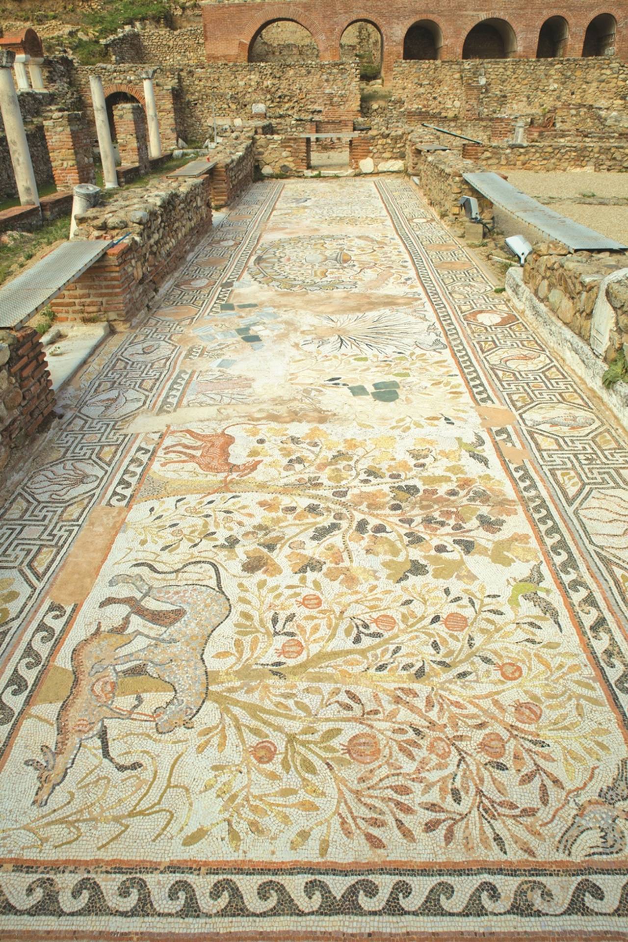
THE ANCIENT TOWN OF HERACLEA LYNKESTIS
Heraclea Linkestis is an ancient town situated on the southern part of the city of Bitola, at the base of Baba Mountain. The name was given by Heracles, the mythical hero and founder of the Macedonian royal dynasty Argeadi while adjective Lyncestis meaning "Linkestidska" comes from the name of the region Lynkestidia in where the city was found. The city was founded in period IV century BC, by the Macedonian king Philip II of Macedon.
Today on the ground of Heraclea the remains of more sacred objects are found, decorated with floor mosaics made in opus sectile and opus tessalatum, dating from the 5th and 6th centuries. It is a small basilica (A), civil basilica (B), the great basilica (C) located about 250 meters from the downtown area of Heraclea, despite that, here are found early Christian and medieval tombs, then portico courtroom from the Roman period (2nd century VN) bath from the Roman period (2nd century VN), theater from the Roman period (2nd century VN), episcopal residence from early Christian times (4 to 6th century), city tap water from the time of Justinian (562). In its place today are held and various cultural events. It is open for visits every day from 8 to 19 pm with advance notice.
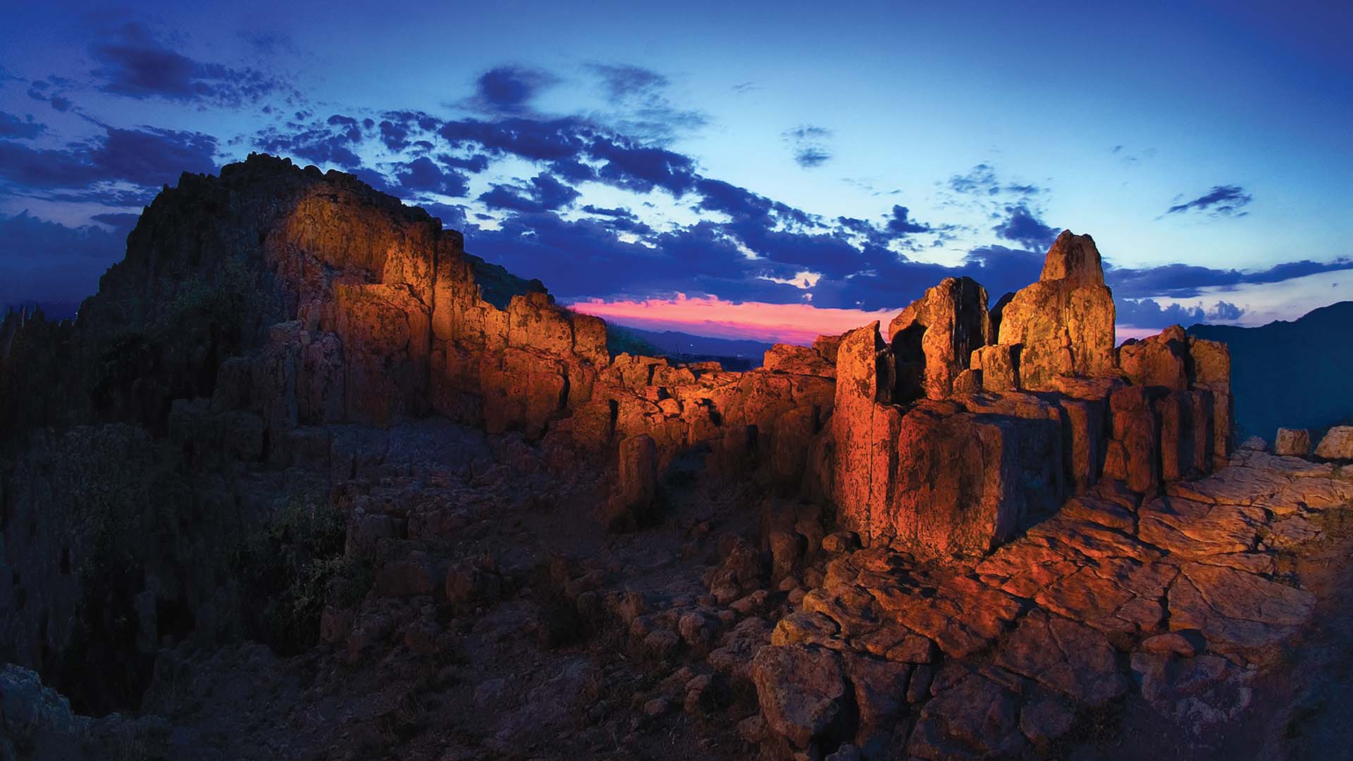
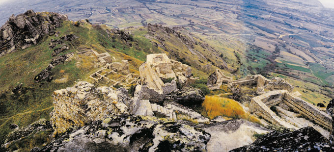
KING MARKO'S TOWERS - PRILEP
Marko's Towers (Markovi Kuli) are situated to the north-west of the Prilep, Macedonia just above the suburb Varoš. The locality of Marko's towers is located in one of the most picturesque medieval citadels in Macedonia. It is a 120-180 m high hill, surrounded by steep slopes covered with minute granite stones. One can reach the upper part of the former settlement from its north and south side.
During the four-decade archaeological research, remnants indicating the existence of an early antique settlement - Keramija, were found. In the Roman period, this small village settlement expanded into the southwest area, which is suggested by the several marble ornaments of an early Christian basilica. The rampart on this terrain dates from the 13th and 14th centuries and is in good condition. The walls are about one meter thick and were built of weaker limestone mortar and rest upon the large limestone rocks. Internal walls separated the acropolis into smaller areas. The palace of Volkašin and Marko was also situated here. Its north gate has a compound foundation, which speaks of numerous addings and reconstructions of the space. According to some historical findings, until the second part of the 14th century and even later, this fortress was defended by only 40 soldiers. The settlement was situated south of the acropolis on a surface of some 3,6 hectares. On its north side, there is a double gate, as well as a large guardhouse between the entrances. On the south wall there are three well-preserved towers. The lowest zone of the rampart consists of a row of short walls drawn in a broken line. In the west side, there are graves inserted into the rock. In the 14th century, this part served as a temporary refuge of the local population from the Turk invasion.
After the death of King Marko, in 1395, this settlement was taken by the Turk guards, and because of that, life in it completely perished. The inhabitants of the former settlement looked for refuge in the near regions. Consequently, at the foot of Marko's towers, a settlement with a rarefied structure developed. It was separated into several quarters and each had its own church. This new settlement from the 14th century took the name of Varoš, a name under which it still exists today.
OHRID, THE ANCIENT LYCHNIDUS
The existence of the ancient town of Lychnidos (today’s Ohrid) is linked to the legend of the Phoenician Cadmus who, banished from Thebes, in Beoetia, fled to the Enhelians and founded the town of Lychnidos on the shores of Lake Ohrid. Lychnidos and its wider area were inhabited by the Illyrian tribes lead by the tribe Desarets. Philip the Second, the father of Alexander the Great in the year 353 invaded this city and it is than that Lychnidos is mentioned, as a name of the Ohrid Lake. An inscription on a stone has been found dating from those days where the citizens are mentioned as Lychnideans.
The eldest historical information about the city Lychnidos dates from the year 217 BC and they are about certain roman military operations on these grounds. Before these events the city has been under the reign of the Macedonian emperors. The subsequent history of Lychnidos is full of interesting events. In the 208 a certain Erop occupied it and in 196 BC it was the Iliric king Pleurat, ally to the Roman conquerors.
Its name is mentioned in 170/169 BC as a Roman military base – period of many combats with the Macedonian king Persey. Ever since the time of the Macedonian kings Lychnidos was known by its coin making. On the one side of the coins there was the Macedonian shield with a star in the middle, and on the other side a kohlrabi and the inscription Lihnidion. Only two of these rare coins have been found, one is in the Institute for protection of the cultural monuments – Ohrid, and the other in Istanbul (Czarigrad).
BARGALA - STIP
The antique city Bargala still remains the main source of material from the ancient period. Bargala city is also mentioned in the acts of Halkedonskiot conclave 415 years. The Name of this city mentions an inscription of 371 yr., Which is a memorial plaque for raising the city's port. The plate was found in the locality Hanche, on the left bank of the river Bregalnica Dummy Karbinci. This monument gives information where the ancient city Bargala was located. The name of the city is of Thracian origin.
The old ancient settlement with urban character called Bargala was located in Dolni Kozjak. This city at the end of the 4th century, served as a military camp of the Roman legions in the conquest of the east. Later was demolished. Residents raised a new city Kozjachka River in Upper Kozjak, as evidenced by archaeological findings.
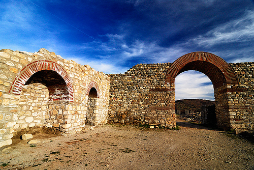
The city became an episcopal seat in the 5-6th century. The city Bargala's was demolished ,but then it was quickly settled. The church tradition of the old episcopal seat continued in Slavic period in this region. More recently, he archaeologists from the Institute and Museum in Stip discovered another basilica from the 6th century. By Bargala having three basilicas. Moreover, it is discovered a winery in the northeastern part of the excavations. Bargala still remains as one of the most ancient historical sites and endless inspiration for archaeologists from Macedonia.
ISAR FORTRESS – STIP
Isar Fortress is a special landmark for the city. It is elevated 150m above the level of the river Bregalnica. In 2009, researchers discovered 30 meters of the tunnel that leads to the top of the Isar River. This confirmed the most famous legend of Shtip, the conquer of the city through a secret tunnel under Isar. Studies in the last period only confirm about the deep history.
The goal is to carry out conservation and reconstruction of the fortress, which by the end of 2011 should be fully lit. It is located on the left side of river Otinja, tributary of river Bregalnica, which passes through the town of Stip.
Location Astibos archaeological has been confirmed by numerous stone monuments from 2 to 6 century. Since than the tunnel originates, blasted through the granite rocks from the top of Isar to Western Bregalnica foot level. Remains of an early Christian basilica from the 6th century have been register in the eastern foot od Isar.
STIBERA ANCIENT CITY
The temple consisted of nave and lobby. Its walls were built of stone and solid plaster, and the foundations were solid and massive. The method of building the nave is typically Roman. From the discovered architectural buildings the ancient gymnasium parcel out. It consists of two separate buildings: Heroes sanctuary and peristyle lobby and Exedra.
SAMUEL'S FORTRESS
The fortress in Ohrid was named after Czar Samuel due the fact that one period of his region he had chosen Ohrid as the capital of his kingdom. The fortress is a profane edifice inseparably connected with the entire history of Ohrid from the oldest periods till day. The town Lychnidos and the fortress for the first time where mentioned by Livy in 209 B.C., during the region of the Macedonian king Phipip V. This data tells that at the end of the 3rd century B.C., the fortress was fully erected and functioned in the crucial moments in the history of the town Lychnidos (Ohrid)
The present day appearance of the fortress with its size most probably was established in the 4th century A.D., as visible from the building technique of the opus mixtum ( brick laid in four and three rows and delineated by lime mortar). Accounts in the historical sources tell that this type of a city fortress had a powerful defence role, and this is why in the year od 479, Theodoric Amali the king of the East Goths during his campaign from Macedonia to New Epirus was not successful in occupying Lichnidos, since “the town was laid in a fortress and had abundant (water) sources inside the walls”.
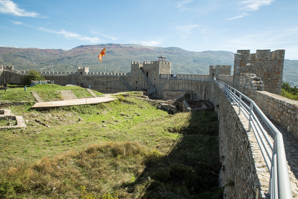
The fortress depending on the historical circumstances was more or less in focus, it was restored or demolished. Nevertheless, the space surface from time of the Late Antiquity remained generally unchanged; accepted for authentic form of the central part, the construction of the citadel that took place in the late 10th and early 11thcentury. This was the period of czar Samuel, when Ohrid became the capital of the first Macedonian – Slavic kingdom, even though in the historical science has viewed this with a different overtone. After Samuel’s death in 1014, without struggle Ohrid was taken by Basil II, so the fortress was left undamaged. In the second half of 14thcentury, namely the period of the governing of the great perish Andrea Gropa with the region of Ohrid, the citadel was restored and enforced.